Back to Where It Began
Contents
The Qilian Mountains are made up of seven roughly parallel ranges, separating Qinghai from Gansu from east to west. Within their broad expanse lie not only the remote Hala Lake and the beautiful Qinghai Lake, but also Xining, the city where I grew up.
Gonghe County and Qinghai Lake
I slept until I woke naturally, had a bowl of proper beef noodles, and brought along some yak yoghurt, a local plateau speciality, for dessert. That was how the last day of the trip began. Perhaps because I knew there were no more challenges ahead, I felt especially relaxed. A comfortable altitude, warm sunlight, busy streets—the familiar feeling had returned.
Gonghe County lies south of Qinghai Lake, about 150 kilometers from Xining, and is the seat of Hainan Prefecture in Qinghai. Its altitude and climate are relatively mild. Qinghai Nanshan, a branch of the Qilian Mountains, separates the Qinghai Lake Basin from the Gonghe Basin, with Qinghai Lake on one side and Gonghe County on the other. It is only about a 50-kilometer drive from the county town to the Erlangjian scenic area at Qinghai Lake, and when crossing Qinghai Nanshan, you can see the whole of Qinghai Lake from above. It is a route I would recommend for a self-drive trip.
Leaving Gonghe County and heading north along the Yijiang Highway, we soon reached Qinghai Nanshan. Near the highest point of the mountain road, just as it begins to descend, there is an inconspicuous parking area beside the road. From there, a short walk uphill leads to a viewpoint overlooking the whole of Qinghai Lake. It is not a well-known place, but I would recommend it. Qinghai Lake is the largest lake in China and is so broad that the best way to see its full extent is from higher ground. There are not many viewpoints with paved roads that can be reached directly by car, and this is one of them. There is no proper walkway or staircase between the roadside and the viewing platform on the hilltop. I did not even realize there was a viewing platform until I reached the top.
A light breeze moved across the land at noon, making the plants rustle. Apart from the strong sunlight, everything was quiet. Sitting on the hill looking at the view, I gradually drifted into a daze. Much later, some other visitors followed the path up. Their laughter and voices brought us back to reality. We checked the time, realized it was getting late, and prepared to head down.
Daotang River and Riyue Mountain
After descending from Qinghai Nanshan to the Erlangjian scenic area, the noise and crowds arrived all at once, replacing the quiet of the previous several days. It was the last day of the National Day holiday, but the roads around Qinghai Lake were still busy. Self-driving tourists with license plates from all over the country were beginning their journeys home, almost all heading toward Xining. After ten quiet days, it took a little time to get used to the crowds again.
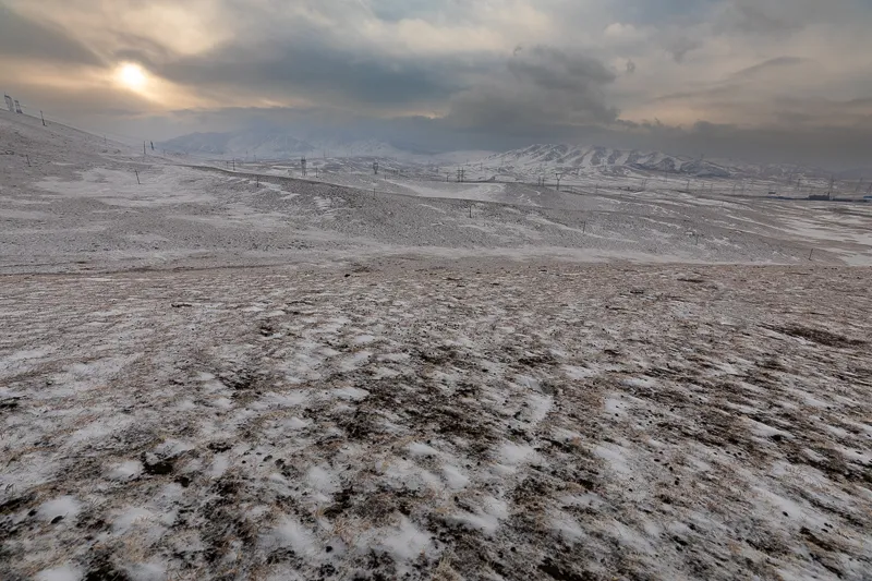
Sunrise at Riyue Mountain in winter, photographed in February 2019
Canon EOS 5D Mark IV
EF 16-35 f/2.8L III USM
F8.0 | 1/160s | 16mm| ISO 100
The road from Qinghai Lake to Xining has been rebuilt and widened again and again. Almost every year, large numbers of visitors coming to Qinghai begin their journeys along this route. The old, narrow and broken highway has been replaced by a wide, straight expressway, reducing the journey from four or five hours to around two. Heading east from Qinghai Lake brings you to Daotanghe Town, where there is an entrance to the Beijing–Tibet Expressway and a direct route back to Xining.
Daotanghe Town lies west of Riyue Mountain and takes its name from the Daotang River. Because China’s terrain is generally higher in the west and lower in the east, most rivers flow from west to east. The Daotang River is the opposite, flowing from east to west before entering Qinghai Lake. This is why it is called “Daotang”, or “flowing backwards”. Daotanghe Town lies on the western side of Riyue Mountain, at the eastern edge of the Tibetan Plateau.
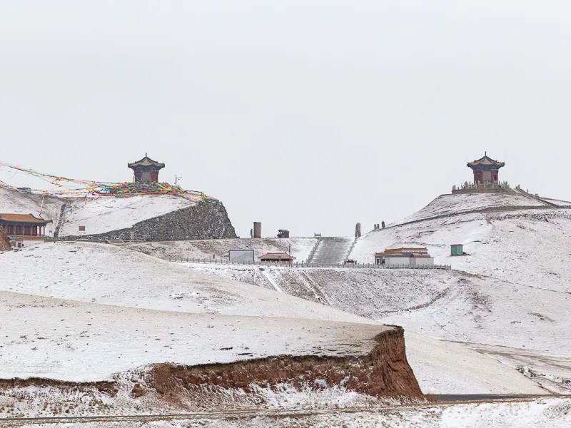
The Riyue Pavilions in winter, photographed in February 2019
Canon EOS 5D Mark IV
EF 70-200 f/2.8L IS III USM
F9.0 | 1/500 s | 200mm | ISO 100
Strictly speaking, the Tibetan Plateau begins west of Riyue Mountain, while the land to its east belongs to the Loess Plateau. Riyue Mountain is not only a boundary between these two major plateaus. It also historically marked the boundary between the Tang dynasty and the Tibetan Empire, as well as the boundary between China’s monsoon and non-monsoon regions, between Qinghai’s internal and external drainage basins, and between pastoral and agricultural areas. If you pay attention while traveling west from Xining, large areas of farmland can be seen before crossing Riyue Mountain. Once over the mountain, the farmland largely disappears and is replaced by grassland, sheep and cattle.
The Tang–Tibet Ancient Road was an important route from central China toward Qinghai, Tibet, Nepal and India during the Tang dynasty and later periods. Riyue Mountain was one of its major landmarks. Traveling west from Chang’an, crossing Riyue Mountain meant leaving Tang territory and entering the area controlled by the Tibetan Empire. In Sacred Mount Gado Jowo, I mentioned that Princess Wencheng crossed Bayan Har Pass on her way to Yushu. Before that, she had also crossed Riyue Mountain. According to legend, while traveling to Tibet to marry Songtsen Gampo, she stopped here and looked east toward Chang’an. Missing home, she took out a precious sun-and-moon mirror given to her by the empress, but accidentally dropped it. The mirror broke in two, with the pieces falling onto two separate hills. Riyue Mountain is said to have received its name from this story. A legend is only a legend and cannot be treated as history. But the story still gives some sense of how difficult the journey from Chang’an to Lhasa must have been at the time.
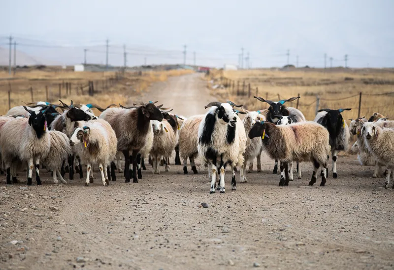
Sheep beside Qinghai Lake
Canon EOS 5D Mark IV
EF 70-200 f/2.8L IS III USM
F5.6 | 1/140 s | 88mm | ISO 100
Today, Riyue Mountain is a well-known tourist site. Two pavilions, known as the Sun and Moon Pavilions, stand on the two hills. Inside are murals and sculptures telling stories of Princess Wencheng’s journey to Tibet. There are also other sites, including the Princess Wencheng Temple and the Looking Back Stone. Interestingly, Princess Wencheng’s name appeared quite often during this trip through Yushu. Temples dedicated to her can be found in many places along the route.
Back to Xining
In my memory, tourism in Qinghai first began attracting wider attention from visitors elsewhere in China through the Tour of Qinghai Lake cycling race. The first race was held in 2002. I was still at school at the time, and the school organized us to sit in the audience at the opening ceremony. Since then, cyclists from around the world have gathered here every July, riding past fields of rapeseed flowers and snow-covered mountains around Qinghai Lake. As the event grew, so did its reputation, and it became one of Asia’s leading cycling races. Its route gradually expanded from Xining and the area around Qinghai Lake into neighbouring Gansu and Ningxia, also helping tourism across western China. Unfortunately, in 2020 the race was cancelled for the first time because of the pandemic.
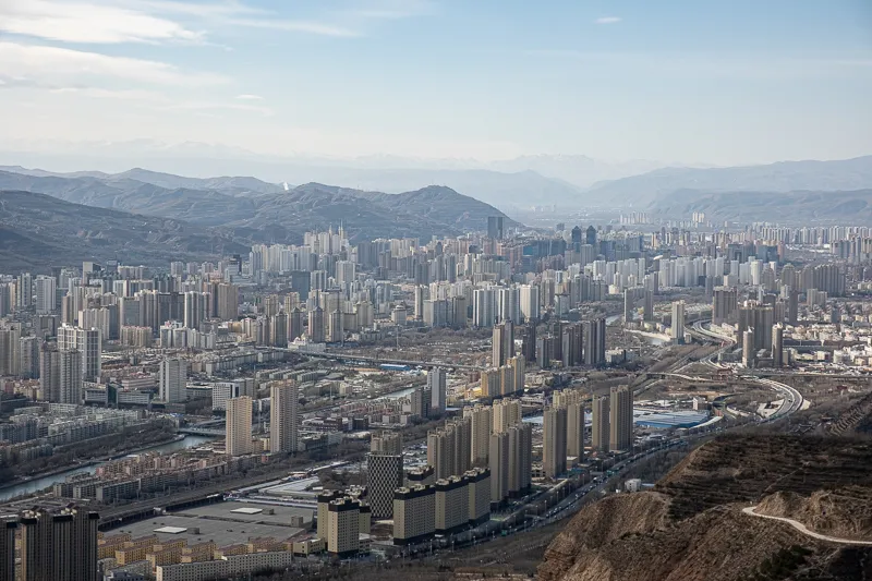
Looking over Xining from Dapanzi Mountain. Riyue Mountain can just be seen in the far distance
Fujifilm XT3
XF 18-55 f2.8-4 R OIS
F9.0 | 1/340 s | 55mm | ISO 160
Another tourism event in Xining is the tulip festival held around June each year. In scale and attention, though, it is far smaller than the cycling race, and its presence has been fading over the years, so I will not go into detail here.
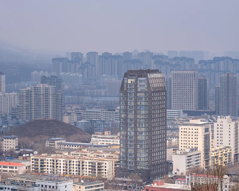
Looking over Xining from Xishan
Fujifilm XT3
XF 55-200 f3.5-4.8 R OIS
F10 | 1/240 s | 70.5mm | ISO 160
Xining is known as the “Summer Capital” because of its cool summers and bright sunshine. At an elevation of around 2,200 meters, it has large differences between daytime and nighttime temperatures and a relatively low average temperature. Even during the hottest part of summer, a blanket is still needed at night, making it a good place to escape the heat. Every June, July and August, visitors from across the country come here, and hotels can sometimes become difficult to book. Xining and the surrounding area also have many well-known natural and cultural sites. Tibetan, Hui, Tu, Salar, Mongolian and other cultures come together here and have formed the distinctive Hehuang culture of the region. There is too much to cover here, so I will not go through them one by one. If I have the chance, I may write a separate series about Xining.
Looking Back
Looking back, the ten-day journey was in some ways incomplete because I did not finish the route around Yushu that I had originally planned. But viewed another way, I gained a great deal from traveling at a slower pace. It gave me the chance to meet more interesting and friendly people. They were generous, open and straightforward, and showed me a very real side of life on the Qinghai–Tibet Plateau. Without those encounters, the journey would have been truly incomplete.
Compared with the deserts and Gobi landscapes of northern Qinghai, southern Qinghai looks entirely different. Green plants cover the land, with flowers scattered among them. Rivers run between the mountains, some fast and some calm, some broad and some narrow. Wild animals live among them, sitting or lying on the grass at ease.
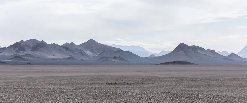
A typical landscape in Haixi, Qinghai: open Gobi
Canon EOS 5D Mark IV
EF 70-200 f/2.8L IS III USM
F20 | 1/100 s | 123mm | ISO 100
Alongside this landscape are the traditional, simple and ritual-filled ways of life of the people who live here. In places where mobile signals and internet access are still limited, the slower pace of life leaves people more time to spend with their children and families, and more time to concentrate on the things they care about. Whether carving a large Buddhist figure into a cliff or engraving scripture onto mani stones, they work with full attention, year after year. Several times, seeing Tibetan mothers playing with their children reminded me of my own childhood. It was simple and happy. I believe those children may one day remember these years as well: days without tutoring classes or electronic devices, with their parents beside them.
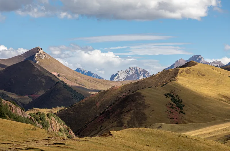
A typical landscape in Yushu, Qinghai: hillsides covered in grass and flowers
Canon EOS 5D Mark IV
EF 70-200 f/2.8L IS III USM + 2X III
F8 | 1/500 s | 155mm | ISO 250
If last year’s journey through Haixi made me marvel at nature, this year’s trip through Yushu gave me, in addition to that, more understanding of people themselves. On the world’s third pole, material life can be extremely limited, while people’s inner lives can still be rich. Reciting scripture, praying, herding, planting, working and harvesting make up everyday life. The people I met only briefly had sun-darkened skin but clear eyes, untidy hair but sincere smiles. They lived with very little, yet there was something in their state of mind that I envied. In an age when life feels increasingly competitive, that kind of happiness sometimes seems separated from me by an invisible pane of glass. I know it is there, but I cannot quite reach it.
The end of the trip also meant returning to busy work. As someone working in software, there are really only two long holidays each year when I can travel: National Day and Chinese New Year. I prefer to spend Chinese New Year with family, looking back on the past year and thinking about the next, so I rarely travel far then. That leaves National Day as the one real chance each year to go somewhere. If writing code in an office is the daily grind, perhaps traveling is the poetry and distant horizons I long for.
· Other Information ·
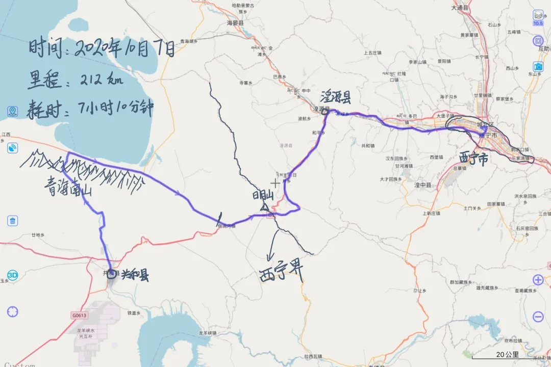
Gonghe County - Qinghai Lake - Xining route
· END ·