The Long Way to Amne Machin
Contents
Amne Machin, standing in the center of Golog Prefecture in Qinghai, is one of the four sacred mountains of Tibetan tradition. Its summit remains snow-covered throughout the year, giving it an imposing presence. The Yellow River, flowing out of Ngoring Lake, bends around Amne Machin, sustaining the animals and plants here and creating a rich ecosystem.
First Sight
It was already nine in the morning when the sunlight streaming into the room woke me. After a steaming bowl of beef noodles, another day had begun. According to the rough plan, today’s journey was to visit Amne Machin first, then decide whether to go to Donggei Cuona depending on the time, before finally taking the expressway back to Xining.
At breakfast, we once again ran into the Patrol convoy we had traveled alongside the previous day. From the conversation over their radio, I learned that they too were returning to Xining today. So once again, we found ourselves among the Patrols, heading north toward Xining. The permafrost sections of the expressway always caught you by surprise. A moment of inattention could send the car briefly airborne. Fortunately, with nitrogen shock absorbers, the rises and dips were rather enjoyable. The Patrols that had been charging ahead earlier, however, slowed down on the permafrost road, perhaps because their suspension was less comfortable with it, and we left them behind.
We bounced our way to the expressway interchange near Huashixia Town. Heading east from here leads to Maqên County, the seat of Golog Prefecture, which we had passed through in Toward Yushu, Crossing the Yellow River Three Times. The Delingha–Maqên Expressway runs directly beside Amne Machin, and from the roadside stopping areas you can see the entire northern face of the snow mountain. If you only want a general look at Amne Machin, the series of stopping areas along the Delingha–Maqên Expressway are excellent places to do so.
Of course, if you want to see the sacred mountain from closer range, you have to take the dirt road from Xueshan Township. But what seemed like the simple matter of leaving the Delingha–Maqên Expressway for Xueshan Township turned out to be surprisingly troublesome. Many of the expressway ramps were still unfinished. According to the navigation route, to reach Xueshan Township we first had to drive east almost as far as Dongqing Township near Maqên County, turn around, return to the Amne Machin toll station, leave the expressway there, and then drive another twenty kilometers or so on dirt roads to Xueshan Township.
Amne Machin
The stopping areas along the expressway near Xueshan Township are all good places for photographing the whole snow mountain. It was here that we saw the long-awaited Amne Machin for the first time. The northern slope was almost completely covered in snow. White clouds crossed over the southern side and then slowly poured down the northern slope, smooth as silk. Amne Machin has an average elevation of more than 5,500 meters. Its relatively gentle form gives it a stately appearance. The range consists of thirteen peaks, with its main summit, Maqên Gangri, rising to more than 6,200 meters. Broad in shape and covered in snow throughout the year, it has an imposing presence. Like sacred Mount Gado Jowo, described in Sacred Mount Gado Jowo, Amne Machin also carries strong religious significance.
According to legend, Amne Machin is the sacred mountain believed to house the soul of the Tibetan hero King Gesar, whose stories are mentioned in The Legend of Duolunduo and Duolunduo, a Hidden Paradise. Whenever the zodiac year of Amne Machin arrives, which is the Year of the Horse in the Tibetan calendar, pilgrims from around the world come here to worship and circumambulate the mountain. It is said that completing one circuit around Amne Machin can cleanse all sins from past and present lives, with merit equivalent to reciting the six-syllable mantra 1.3 billion times.
In Tibetan, “Ani” means “grandfather”, and can also carry meanings such as happiness and fearlessness; “Machin” means the highest great mountain at the source of the Yellow River. After flowing out of Gyaring Lake and Ngoring Lake, described in Leaving Yushu, Following the Yellow River Downstream, the upper Yellow River bends around Amne Machin. The mountain has 57 glaciers covering 125 square kilometers, among which Halong Glacier is the longest and largest glacier in the Yellow River basin.
Xueshan Township
After all the detours and more than an hour lost, we finally left the expressway at the Amne Machin toll station. The interchange itself was not yet complete; construction crews were still installing road signs along the ramps.
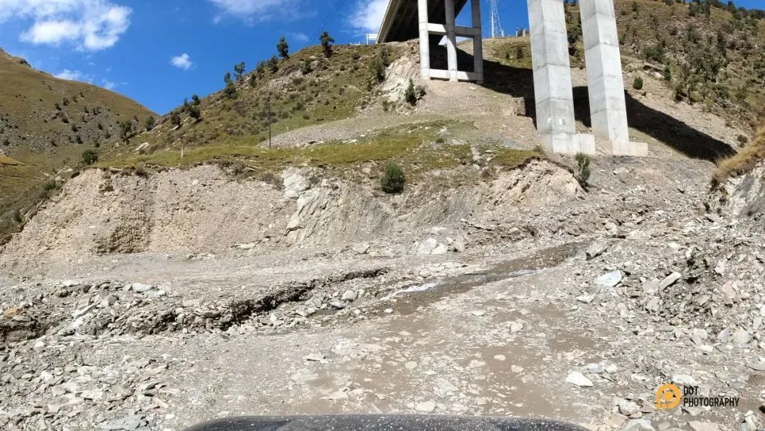
A section of road washed away
DJI OSMO ACTION
The first stretch of dirt road after leaving the expressway was mostly flat, with a few gentle rises and falls, and was enjoyable to drive. But after passing Yangkehe Village, the road became rough and difficult again. Like the road to Duolunduo Village, it ran through a canyon, though the river here was narrower and the road much rougher. We repeatedly came across sections where half the roadbed had washed away, leaving barely enough room for a car to pass. It was challenging but exhilarating.
The dirt road wound along beneath the expressway and passed several times under its elevated bridges. After about twenty kilometers of bouncing around, we finally reached a section of asphalt belonging to Xueshan Township. We filled the tank at the gas station and continued along the road running parallel to the expressway. The asphalt ended at the expressway ramp. To continue farther, there was no choice but to return to the broken dirt road.
The Sacred Mountain
Beyond Xueshan Township, we encountered far more independent road-trippers. The dirt road was also much wider and easier than the earlier sections. About ten kilometers west, we reached a three-way junction with one branch leading into the Amne Machin range. Besides the road from Xueshan Township, the other two led to Dangxiong Glacier and Halong Glacier. We decided to visit Dangxiong Glacier first, then return to the junction and continue toward Halong Glacier and Xiadawu Town.
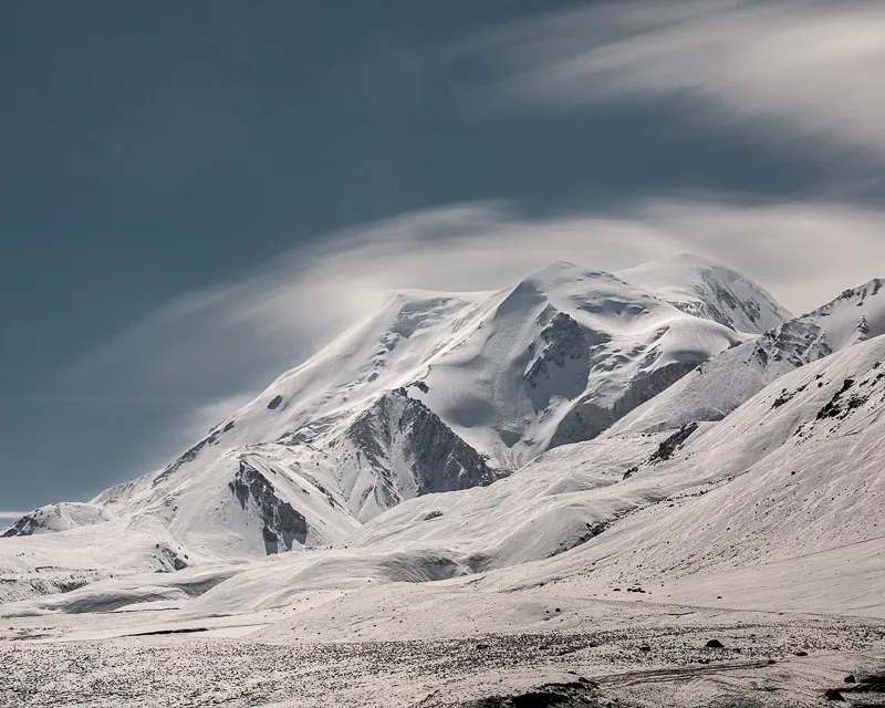
Sacred Mount Amne Machin
Canon EOS 5D Mark IV
EF 70-200 f/2.8L IS III USM
F18 | 68 s | 80 mm | ISO 100
The road toward Dangxiong Glacier was not wide, but the scenery along it was beautiful. Snow-covered peaks appeared and disappeared in the distance, while unknown wildflowers grew on both sides of the road, fresh and bright. The deeper we went, the narrower the road became and the more pebbles appeared on the surface. Driving through these winding plateau meadows was strangely calming: a slightly bumpy road, cool dry air, harsh sunlight bringing a faint burning sensation to the skin, and every now and then the scent of an unfamiliar plant drifting past. Everything in front of us seemed small and delicate beneath the enormous snow mountain in the distance.
After crossing a broad, flat riverbed, we were already quite close to the mountain. We drove a few hundred meters through a field of huge rounded stones before the route became impassable by car. I put on my backpack, picked up the camera gear, and continued on foot toward Dangxiong Glacier, but eventually stopped at an earthen slope. The wind was too strong and the temperature too low. Reaching the glacier and walking back would take at least an hour and a half. The sun was already low, and with the rest of the journey still ahead, we decided to turn back.
We drove the car back to the riverbed, boiled some water and made a cup of instant coffee, looking up at the sacred mountain and hoping we would meet again. Then we drove back to the three-way junction and headed toward Halong Glacier. According to the plan, after visiting Halong Glacier we would continue to Xiadawu Town and join the expressway there for Xining.
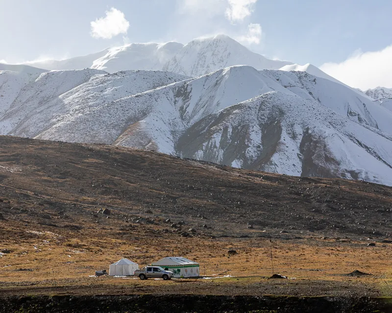
Herders beneath Amne Machin
Canon EOS 5D Mark IV
EF 70-200 f/2.8L IS III USM
F16 | 1/100 s | 88mm | ISO 100
Halong Glacier lies right beside the road, so seeing it requires little additional effort. The only obstacle is the rough dirt road. By the time we reached the glacier, the sun had already dropped below the horizon. There was clearly no longer enough time to hike to the foot of the glacier, and so for the second time that day, we missed the glaciers of Amne Machin.
Standing on the hillside, I took a few photographs with my phone. With darkness almost upon us, we hurried toward Xiadawu Town. The dirt road around Amne Machin was extremely rough in places, with washouts and collapsed roadbeds appearing from time to time.
The Final Ordeal
According to the map, we were not far from Xiadawu Town, so I relaxed and continued forward without much urgency, listening to music. But it soon became clear that we had been careless. As soon as we reached the connecting road from Xiadawu Town to the expressway, something seemed wrong. A toll station should normally have been brightly lit, yet everything ahead of us was completely dark. We cautiously drove a little farther until a barrier suddenly emerged from the darkness and put an end to the idea of continuing. It was a dead end.
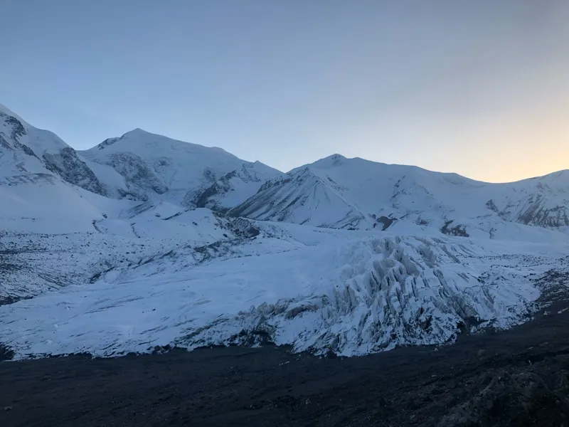
Halong Glacier on Amne Machin
iPhone XS
On the satellite map, the road ahead clearly connected to an expressway ramp, but the ramp had not opened. After calling the expressway administration, we learned that Xiadawu had no toll station. The news left us with two choices: drive west to Huashixia Town or retrace our route east to Xueshan Township. Returning to Xueshan Township meant facing the narrow road and partially collapsed sections again, with no guarantee that the toll station there would still be open. The road toward Huashixia should have been wider, but we knew nothing about its actual condition. After weighing the options, we headed west toward Huashixia.
We left Xiadawu Town at around 8:30 p.m. By then it was completely dark. The asphalt and streetlights disappeared into the rearview mirror as soon as we left town, and the road became rough and uneven again. Worse still, the moon had not yet risen. The entire world was black apart from the area illuminated by the headlights. This was the first time we had driven an unplanned dirt road at night. With visibility so limited, several times we drove for a while only to realize that our current position did not match the tracks on the satellite map. We would then turn around, return and try another road. After two hours of this and around forty kilometers of driving, we finally saw the interchange between the Delingha–Maqên Expressway and the Yushu–Gonghe Expressway near Huashixia. Only then did I begin to feel a little more at ease.
But the final kilometer took almost another half hour. Road construction had made the tire tracks shown on the satellite map completely useless. Temporary construction roads and tracks for engineering vehicles crossed everywhere, and in the darkness there was no way to know which one would actually lead to the asphalt road ahead. We kept trying, turning back, trying again, then returning again. At one point, we had driven all the way beneath an expressway ramp, only to find another dead end. What finally rescued us was a car approaching from the opposite direction. Following the direction it had come from, we finally found the correct track and reached the paved surface of G214.
We did not join the expressway at Huashixia because doing so would have required driving south for a while and retracing our route. Instead, we followed G214 north across Jiangluling to Wenquan Town and finally joined the expressway there. By then it was already after 11 p.m., and reaching Xining that night was clearly unrealistic. We decided to stop in Gonghe County, Hainan Prefecture, for the night.
The Ela Mountain Tunnel is a notable feature of the Yushu–Gonghe Expressway. It was China’s first tunnel bored through high-altitude permafrost and marked a milestone in the country’s permafrost-tunneling work. After another three hours on the expressway, we finally reached Gonghe County shortly after two in the morning, bringing a difficult day to an end. Lying on the hotel bed, the whole experience still felt slightly unreal. I was also strangely excited, and I do not know how long it took me to fall asleep.
· Other Information ·
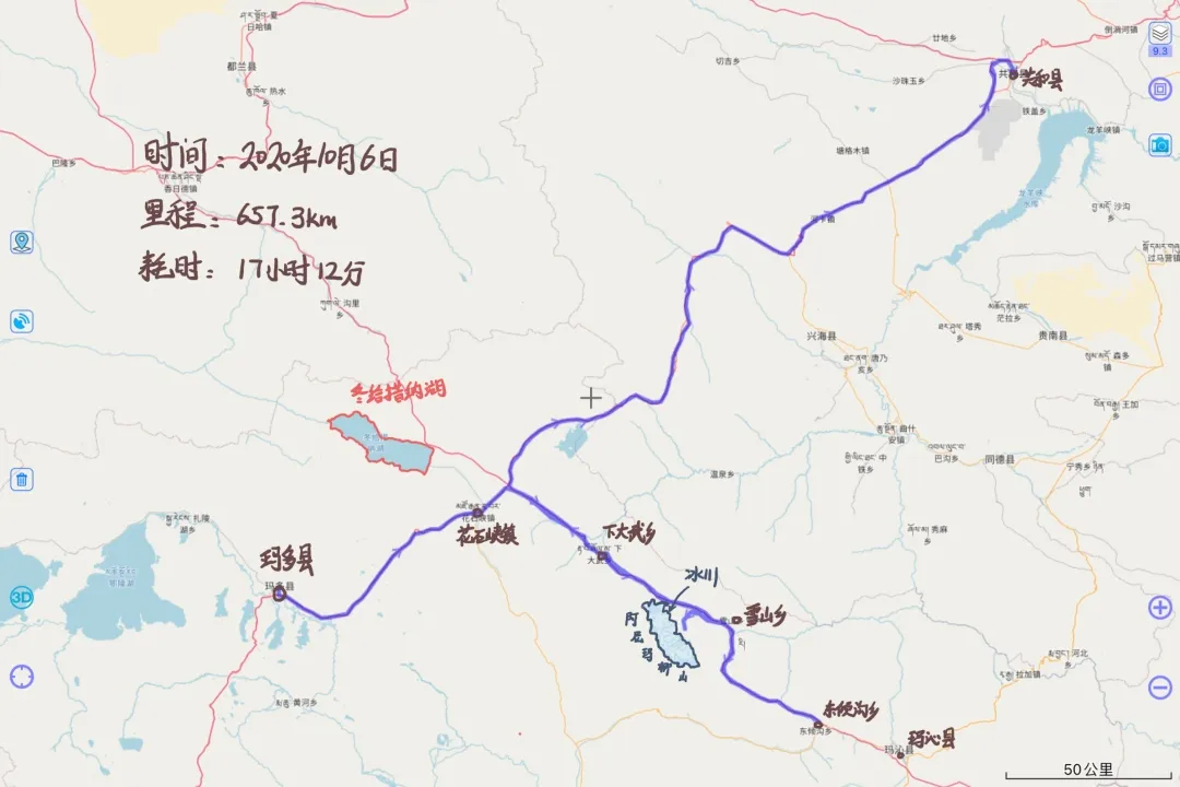
Madoi County - Amne Machin - Gonghe County route
· END ·